Mabel’s Girls

A new trekking club in Dubois WY is named after an early businesswoman of note if not distinction.

For nearly a decade, I’ve usually hiked these hills alone. In only the past year, I’m pleased to report, I’ve found many women to join me in exploring the delights of the Wind River Valley.

snowshoes
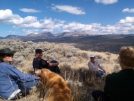
More accurately, they’ve invited me to join them. Today I headed for the hills on snowshoes with six other women, most of whom moved to Dubois within the past few years–from Oklahoma and Louisiana, Massachusetts and California by way of Arizona, and in one case back living in Dubois again, after leaving town for a decade to explore the country by RV and considering many other locations in which to settle permanently. Here they are

Members of the ladies’ trekking club propose to call ourselves Mabel’s Girls, after the local name for the large hill that looms over our homes. Perhaps my favorite hike is the steep climb up the public land on the northeast side of Mabel’s Hill, which rewards you with a spectacular view of the Dunoir Valley when you reach the long high plateau at the top.

Mabels Hill
View atop Mabel’s Hill

In 1932, one of Dubois’ early entrepeneurs, Mabel McFarland, opened the Long Creek Ranch and Tavern along the highway just off the highway at the western end of the hill. For many years, the tavern was popular with local cowboys and loggers as a place to stop for a drink and entertainment after a hard week’s work on the range or in the mountains.

One friend told us that when he was working on a ranch nearby many years ago, he and his buddy would occasionally ride over to Mabel’s at the end of the day, penniless and thirsty. She would stake them to one beer each and then boot them out.

Mabel features as “one of the most memorable characters” in Mary Allison’s iconic Dubois Area Local History. A photo shows Mabel standing in front of her establishment wearing trousers and a blazer, smiling, her windblown hair framing her face.

“There were many who remember those fun days,” Mary wrote, “particularly when the Dubois Roping Club ended up at Mabel’s for drinks and dinner. She was a great hostess and lots of fun.”

I have not taken time to track her history further, but I have heard that Mabel opened her new tavern 15 miles to the west of Dubois after locals who objected to her business forced her out of town. There are reports of cat-fights on the bridge in the middle of town between women who supported Mabel’s business and others who opposed it. But this is all merely hearsay.

MabelsFireplace
Fireplace viewed from US Hwy 26

Dubois Area History reports that Mabel’s tavern was badly damaged in a dynamite explosion in 1957, and burned to the ground in 1958 or 1959. There are those who say that a stone fireplace visible from the highway at the base of the hill stands as a reminder of the tavern, but our ex-cowboy friend disputes that this was the exact location.

Mabel’s Girls has no formal standing as an organization and no bylaws. But we have discussed the terms under which we might allow men to join our treks. Some members of the club joke that we should charge them for the privilege, or at least require them to break the trail.

We also note the charming exhibit currently on display at the Dubois Museum, which features dolls made from vintage clothespins depicting noteworthy women in Wyoming history. Members of Dubois’ Top of the World Homemakers Club hand-crafted the dolls in 1989, in honor of Women’s History Month.

You see Sacajawea at lower left in the image below. The first female judge in Wyoming is included, as well as the first woman to vote in Wyoming and a female doctor who dressed as a man to avoid attracting attention and unwanted comments.

Mabel McFarland is not among them.dolls

Perhaps the women who inspired the dolls are better role models for the little girls most likely to enjoy seeing them. But as one member of Mabel’s Girls commented during our winter trek today, it just wasn’t so easy for a woman to start her own business back in the day.

And without a doubt, women like Mabel were also part of the history of the West.

© Lois Wingerson 2016

Want to read more about living in Dubois? Sign up at the top of the right column.

The Wild Life in Dubois, Wyoming

More joys of winter hikes: Abundant deer and tasty snacks.

DeerInTrail This gal crossed our path the other day. A few seconds later, the rest of the family bounded after, too fast for me to catch their pictures.

The master of her clan stood watch afterward, just over the ridge on the right, staring warily at us as we proceeded uphill. Then he too wandered off.

The dog didn’t seem to notice. He never chases deer, apparently preferring someone else to do that.

Deer are nothing unusual in the countryside anywhere, of course. We must be wary for them as we drive the highway. They have been so abundant nearby in town that last year the council decided to have hunters cull the herd. People could reserve some of the venison at the local butcher.

deerWe don’t see them often on our property for some reason, although last year the dog did alert us to one brash creature who had approached the front door to enjoy the flowers in my planter.

My friend Karen tells me that all the houses on her side of the highway seem to have the same lawn ornaments. They reposition themselves from day to day.

One good thing about being here in the winter is that we don’t need to worry so much about bears when we hike. The bears are supposed to be sleeping it off, although a cub has been sighted in town recently. As you can see from the picture at the top, it’s been mild lately. I guess someone woke up before the end of naptime.

TelescopeKaren told me that people had been seeing lots of elk lately on the ridge to the east. I told Mark about this, and he set up the telescope facing out the east window. We’re not used to seeing them on that particular hillside. Sure enough, there they were. ElkInScope

Seeing “lots of” elk is a relative statement. Our friend Leon, a retired cowboy, says they used to see them up on that ridge by the hundreds when he worked for the Cross Ranch. Ab used to tell him to ride up there and drive them off.

In the warmer months I often scare up these beautiful, elusive creatures when I hike uphill. They always bound away out of sight, of course, but a lone male will often stand guard behind, chattering loudly at the dog and me to stop trespassing. They don’t seem to understand the concept of “public land.”

The wolves and bears have devastated the elk and moose population here, alas. (But why not the deer? Perhaps someone will write in and tell me.)

Moose are so rare that sightings are cause for celebration, while the published oral histories of the area tell us that they were abundant a century ago.

I’ve read about the explanations for this shift in the natural history of the Greater Yellowstone region, but that’s a better topic for another author. I merely note with regret that I encounter far fewer moose than when we came here less than a decade ago.

A few years ago I did see one up close during my morning bicycle ride, to my sorrow. Someone had struck it on the highway just west of Stoney Point. I wanted to hold a funeral.

BennyLeaveIt1The dog and I have somewhat different sentiments about the actions of nature’s predators, of course. He often comes trotting after me proudly dragging something far too large to transport, or stops to enjoy a snack from a disembodied joint.

In the warmer months (as you see here) I have to prevent him from indulging in these pleasures, for his own safety. Another good thing about winter is that these treats are frozen, and probably safe to consume.

He knows he’s not allowed to bring them into the car or the house. But I am tempted to import one of these bones back to Brooklyn so that he can show them off at the dog run.

(“You and your silly tennis balls! You think that plastic thing from the grocery store is a bone?“)

© Lois Wingerson, 2016

Please sign up at the top of the right column if you’d like to see every new post on Living Dubois via email.


Remotely and Wildly True: Of Dubois and Distance

Did National Geographic really call Dubois WY the most remote town in the lower 48? How remote is it, actually?

HighwayGoogle “Dubois WY” and you’ll soon encounter a statement that it has been designated the most remote town (or sometimes the second remotest town) in the lower 48 states. Often this distinction is attributed to National Geographic.

When we moved to Dubois, my husband and I quickly took up calling it one of the most remote towns in the lower 48 when we described it to friends. We even trotted out some criteria, whose origin I no longer recall: Farthest from the nearest Interstate, fewest traffic lights (none), fewest number of highways that run through it (one), distance to the nearest large town (about 70 miles), or proportion of land within a 360-degree radius that is publicly owned (who knows, but lots).

But is this distinction actually deserved? How remote is Dubois, and compared to what and by which criteria? Last summer I began to study the question, with interesting results.

First, I couldn’t find any such statement about Dubois in the archives of National Geographic. And many other towns lay claim to the distinction of being most remote.

I turned to local sources, Dubois town hall and the library. Sandy Hurst at town hall offered up text from a 2011 press release about Dubois:

“A place considered by National Geographic as the most remote town in the lower 48 states…  it perches on the edge of several wilderness areas and is surrounded by national forests.”

This traced back to a strategic plan for Dubois by the Foundation for Urban & Neighborhood Development of Denver, Colorado, dated 1986. The report said that Dubois had been “recently identified in national news media coverage” as the most remote location in the lower 48–the same unconfirmed designation that I was already seeing, albeit even older.

Anna Moscicki at the library turned up a wonderful quote from the memoir of Ethel Waxham, mother of the geologist David Love who defined the geological history of the Yellowstone region. Waxham wrote about her arrival in Wyoming by stagecoach in 1905:

“The other passenger beside myself was a woman of fifty or sixty, white-haired, face weather worn, bright brown eyes, Mrs. Welty. She was post mistress at Dubois, the post office farthest from the railroad of any in the U.S.”

Delightful, written when the railroads were still expanding, and perhaps an insight into the town’s perception of isolation. But not that relevant today.

In the course of promoting Living Dubois on Twitter, I was fortunate to gain the interest of Marilyn Terrell, chief researcher for National Geographic, who has also been unable to find any source for that attribution of Dubois’ remoteness by her publication (so we ought to stop using it). But she did point me to an article in Smithsonian magazine describing what truly may be the most remote settlement in the lower 48: the community of Supai, Arizona, located at the base of the Grand Canyon. At the bottom of that 3,000-foot crevasse, it is reachable only by mule train, which is how they get their mail.

But Supai isn’t really a town: It’s designated by the US Census Bureau as a “census-designated place,” which is the Bureau’s term for a populated place that is not an incorporated village and has no municipal government. So does Dubois still qualify?

Overlook7Author Henry Grabar on the website citylab.com looked into which towns were most remote by the criterion of being farthest from the nearest Interstate highway, honoring Key West, Florida, as being farthest as the crow flies, and Copper Harbor and Eagle Harbor, Michigan, (251 and 238 driving miles from the nearest Interstate), with an honorable mention to Paisley, Oregon (209 miles) due to the sheer difficulty of driving to the big highway.

Dubois is “only” about 173 miles from the nearest Interstate, at Idaho Falls, and is interestingly equidistant from Interstates at Rawlins, Casper, and Livingston MT (200, 199, and 199 miles, respectively). But considering only towns that are completely surrounded by Interstates (rather than having a national border or large body of water on at least one side), I do wonder whether Dubois might qualify as having the largest average distance to the Interstate in all 4 directions (193 miles).

If you aren’t familiar with Dubois, please be assured that you can buy plenty of groceries and hardware supplies in town, and it’s even easy to find a cafe latte. And by that other criterion of remoteness, Internet access, Dubois is marvellously well-connected. You feel the remoteness mostly by your proximity to all that wilderness.

Speaking of which, there is one remoteness criterion Dubois can legitimately claim without dispute: It is TwoOceanPasscloser than any other town in the United States to the spot in the lower 48 that is most remote from any road, and therefore reachable only on foot or by horseback. This is Two Ocean Plateau in the southeastern corner of Yellowstone Park.

This spot has been designated by the United States Geological Service as the location in the “coterminous” United States that is most distant from any road (the trailhead is at Moran, an unincorporated community). Dubois is 44.1 miles from Two Ocean Pass as the crow flies, and the plateau is farther north. Jackson is 48.8 miles away.

There is one criterion for remoteness by which Dubois fails miserably. The residents are hardly remote in their behavior toward other people. It’s one of the friendliest places I’ve ever encountered, which is one reason we go all that way to get there.

@ Lois Wingerson, 2016

You can sign up at the top of the right column to see new posts on LivingDubois via email.


The Great American West in Your Vest Pocket

How many times I have longed to get away on vacation! But leaving Dubois this year only makes me appreciate it all the more.

cactusesHow well I remember all those vacations before I retired, when I longed for a chance to get away. How odd to get away this year, and find I spent so much time longing to get back.

During our trip to the prickly, alien world of southern Arizona, I began to understand why many of us who first come to Dubois to get away find it so difficult to stay away once we have left. Visiting the Sonoran Desert Museum in Tucson, all I wanted was to return to that softer high-mountain desert back home up north, made so much gentler by the sight and smell of sagebrush and the waves of grass.

But it wasn’t merely that I missed the familiar landscape. There’s much more to it than that.

I learned what it looks like around Phoenix and Tucson. We drove through many beautiful mountain passes, and I saw the actual OK Corral in Tombstone. It was okay.

Butch_Cassidy_mugshot
Butch Cassidy: mug shot from Laramie State Prison. The ranch he must have been missing during his only prison term was right here in Dubois.

So many others, like us, were also out there, covering vast amounts of territory to satisfy their curiosity about the real West. They could have seen it so much more simply and quickly, within a few hundred square miles, by just going to Dubois. (Why aren’t we pointing this out to people?)

Think about it: All the eras of Western geology. Dinosaurs nearby in Thermopolis. Native American prehistory in the mountains all around. Then the history: Mountain men, cowboys, and our very own famous outlaw, Butch Cassidy. Railroads? The ties were hewn right here. A great restored ghost town and working (though failed) gold mine, just around the corner in South Pass City. Not to mention the greatest American National Park, a long day trip but really so close.

As to the landscape, we traveled over many days to tour Arizona, and here’s what we found:

PaintedDesertNPS
Painted Desert. Luckily, because there is so little vegetation here (I’m guessing), our dog was actually allowed on the path, unlike so many other National Parks. But we aren’t allowed off the path.

Painted Desert: Yes, you can see it from your car in the Petrified Forest National Park, or hike overland deep into the adjoining Arizona back country to explore it (no highways nearby). But there’s nothing like actually scrambling up these multicolored slopes and exploring the rambling draws. I do it all the time, close to home.

PaintedHills
Our own painted desert in Dubois, just one small part of it. There are many places around town where you can hike these fabulous badlands and see the formations up close.

“This should be a state park or something,” said a neighbor on one such hike. Lucky for us, most of it isn’t anything official. It’s just delightful.

NewspaperRock
Petroglyphs on Newspaper Rock, Petrified Forest National Park. You might get this good a view with a great set of binoculars.
Petroglyphs Dubois WY
Petroglyphs in a valley near Dubois, about a half-hour drive from the middle of town.

At the end of a short paved path, using a telescope provided by the Park Service and looking down and to the right, in good light you can catch a glimpse of the petroglyphs on Newspaper Rock in the Petrified Forest National Park.

In Dubois, tourists can contact the local museum for a guided tour to see our many local petroglyphs, right up close. I think ours look better, but then I could actually see those.

Undoubtedly I’ll keep traveling. But if I long to keep learning about the true West, I know exactly where to go (or stay).

Unless I suddenly develop a passion to be surrounded by cactus.

Want to see more from LivingDubois? You can receive new posts by email. Just sign up using the link at the top of the right column.

© Lois Wingerson 2015

Joys of Dubois: The Midtown Mountain Overlook

It certainly says something about the hiking trails around Dubois that I could begin to find the views from the town overlook boring.

Overlook4 It certainly says something about the hiking opportunities in and around Dubois: By now,  the scenic overlook in the middle of town seems a bit of a bore to me, because I’ve traipsed so much of it so often.

But heavens, what you can see here!

You can drive to the top, or take the rather steep trail up from the parking lots halfway up, as you see in this picture.

The huge two-level butte is literally in the middle of town. It looms over the main section of Dubois, ascended by a steep dirt road that you reach by taking a right turn from the highway, just as you begin to head west out of town.

Overlook1Here’s what you see from the top, looking east. (That’s the top of the foot trail at the lower left.) You may want to stop a moment and sit on the log guard rail to catch your breath. There are informational signs about what you’re looking at.

You can see much of the town off to your right (not visible here), or the eastern edge of town in front of you (visible in the center of this photo).

But what really pops are the mountains all around you. This is one of the few places on earth where you can see all three mountain-building processes from one location, according to geologists at the Miami University of Ohio field station near Dubois. In the photo above, at right, you can see part of the range above Whiskey Basin, rises from a wonderful valley filled with lakes dug out by a glacier. There’s a splendid hike to a glacial lake isolated at the top.

The Absaroka mountains are volcanic (dumped by the massive Yellowstone eruption about 640,000 years ago), are easily visible from the western edge of the Overlook (not shown)Overlook7.

Here, in the third photo, you see in the distance the Owl Creek Mountains to the north and east, which are tectonic (the result of subsurface plates sliding over each other).

Behind you, looking to the south from the Overlook, you would see the long hump of the Wind River Range, which is sedimentary, rising behind the town. These mountains have  eroded over the ages from a time when this area was, incredibly, ocean floor.

I’m told you can still find marine fossils over there. Haven’t had time to investigate.

Overlook6From many vantage points on the Overlook, your closer view takes in these fabulous badlands. I’m always tempted to go sliding down one of these draws. (It’s difficult to envision a steady stroll down.)

Once in a while, if it’s hot, I’ll venture down a few yards to let the dog have a rest in the shade of a sagebrush plant. I never tire of seeing these magical formations.

Overlook2Last year Dubois Area Rails & Trails added a bike route up here. It was startling to see many new avenues where I used to blaze my own way. Haven’t seen many bikers up there yet, but I did see plenty of bike tracks as I walked the trail.

It’s intriguing to inspect the rocks dropped along the Overlook3trail over the millennia. Did this one sit at the bottom of an ancient ocean, or did a glacier drop it? I have no idea. Like so many other stones on so many paths in the Wind River Valley, it’s intriguing in its own right, however it got here. (Kinda like most of my neighbors, come to think of it.)

Overlook5One thing I’ve never observed here is quadrupeds, other than my faithful canine companion and other dogs brought up here for the chance to sniff around.

But evidently other mammals are here sometimes when we’re not.

The other exception, occasionally, is horses (as you can tell from the roadside sign below). The race course is on the second level, appropriately rustic and informal. The shack sells beer and hot dogs.

OverlookSign.
Want to read more about living in Dubois WY? You can read weekly updates via email using the link at the top of the right column.
© Lois Wingerson 2015

Joys of Dubois: Mountain Shoshone Heritage (Part 1)

Those nearly traceless migrant people who left no written records clearly loved this valley and knew how to use its scarce resources to live well.

New to this valley, I quickly became captivated with its first residents: Those people with the musical name, the Mountain Shoshone.

SheepTrap5_090515 Elusive and misunderstood when they existed as a tribe, they’re now largely lost to oral history. (Some residents of the nearby Wind River Reservation may carry their blood, but their culture has vanished.)

Many people here treasure that heritage, because those nearly traceless migrant people who left no written records clearly loved this valley and knew how to use its scarce resources to live well.

The archaeologists have offered up a few relics that survive them: Bowls made of soft soapstone, flakes and points used to hunt, scant signs of their villages at treeline (of which I will tell much more later), and these: Their sheep traps, some of which are still remarkably intact.

They were sometimes known as “Sheepeaters,” because they hunted the bighorn sheep that still travel these hills. The first picture shows State of Wyoming archaeologist Dan Eakin walking along a drive line, one of the pincers of timber that the Shoshone laid over many of the high slopes to herd the sheep, passively, toward a high ridge.

SheepTrap2_090515Cresting the ridge, the sheep would find themselves wedged between lines of timber and driven with no escape route toward a pen. There by some means (I believe we still don’t know how), the hunters dispatched the sheep.

Today, with a dozen other hardy folks, I hiked a very steep slope toward a ridge to see the remains of some Shoshone sheep trap systems. “I don’t want to get personal,” Eakins called out as we were huffing our way up the slope this morning, “but I’m 57. Is anyone here younger than me?”

We called out our ages. Nobody was. The woman who organized the hike is 73.

The wood in the sheep traps has been dated to the 1760s–before the Revolutionary War, Eakins said, and well before Lewis and Clark explored this general territory in 1804-1805. He called them some of the oldest human structures in the American West. High and generally dry, they remain remarkably intact.

The second picture shows some of my friends at the end of another drive line, admiring a catch pen. The next picture shows the catch pen itself. A tree has grown up inside it, long after the last sheep was bludgeoned inside. SheepTrap3_090515

It’s sort of fallen in, but can you see the ramp that the animal had no choice but to climb?

Below you see the trap from the side. From a distance, it may look like a pile of rubble. But close up, it’s clear that this was built intentionally. But built by non-white people, long ago, almost certainly: There are no signs of ax marks, and certainly no nails. All of it was dead wood, put to very good use.

SheepTrap4_090515For years the purpose of these structures (and in fact the identity of the builders) was mere conjecture, because nobody ever found arrowheads, or bones, or any signs of butchery nearby. But a few years ago Eakin and others found a sheep processing center near Greybull, to the north, filled with artifacts identified with the Shoshone.

Why locate the processing center remote from the sheep trap? Makes sense, Eakin said. It was probably smelly. Might have spooked the sheep away from the drive lines somehow.

Anyhow, it probably wasn’t so far back in the day. Now it’s about a 4-hour drive around to Greybull, but the Mountain Shoshone didn’t drive around. They walked the ridgelines, which are much more direct.

Want to read more about living in Dubois WY? You can read weekly updates via email using the link at the top of the right column.

© Lois Wingerson 2015

The Lore of Lumber

Not many of these relics remain from the tie hacks, whose dangerous work helped to build the West but also, in a sense, the town of Dubois.

Flume1Near the bottom of a long series of switchbacks, hiking down from the top of a large overlook, we approached a stream running through the base of a canyon.

My hiking companion looked down from the last switchback. “What’s that?” she asked, pointing to this structure.

I was relieved to find it still intact — not fallen down and washed away or, God forbid, pilfered. Few people know about this last remnant of a flume. There aren’t many of these relics left from the watercourses constructed more than a century ago by the tie hacks, whose highly dangerous work not only helped to build the railroads that made the West but also, in a sense, created the town of Dubois.

In the early days of the last century, the tie hacks cut lumber from these mountains and fed the logs via these flumes to the Wind River, where they were floated down to Riverton to be stacked and sent on by rail. All of the tie-hack work was demanding, and much of it was potentially deadly. (Read much more in Knights of the Broadax.)

The tie hacks lived in camps in the mountains above Dubois, using the long cold winters to fell the trees and the warmth of spring to direct the logs into the flumes and down toward the river. Their stories are the kind that make you marvel at those who built these communities. The tie hack villages and their stores and post office disappeared long ago, the community essentially relocated to Dubois.

One of the tie hacks, Fritz Stevens, was still alive to tell the story when I moved to Dubois. Their achievements and exploits still survive in exhibits at the Dubois Museum, in the annual Swedish Smorgasbord (celebrating dinners in the tie camps, many of whose residents were Scandinavian), MuseumDay2008_5_FritzStevens(seated)KnotTyingand in the surnames of many descendants who still live in town. In this picture you can see the late Fritz Stevens, sitting down with his cane and somewhat obscured by the shade, demonstrating knot-tying at a recent Museum Day.

I once heard Fritz tell of enduring a logging accident that sent a pole into his mouth, knocking out several teeth and letting loose lots of blood. There would be no talk of a trip to a medical clinic, of course: There was no medical clinic. He stopped the blood, took a rest, and got back to work.

The tie hacks are gone, but the lumbering goes on. Here’s the house my neighbor is building slowly, all by himself (with help from friends) with logs left over from his long life in the industry. His wife is Fritz Stevens’ neice. Although the couple grew up in this area, they spent several years in Alaska working for the timber industry, and they have some hair-raising stories to tell about the danger of that work. As I gaze at the huge logs that make up my own house, I think now of the perils that must have been involved in providing them.

Logger2 Logger1

It’s been many decades since the lumber mill, once the basis for Dubois’ economy, closed up shop. But logging trucks still rumble down the highway every day, and things are looking up: The US Forest Service recently reopened logging in the Shoshone National Forest, so that some of the many trees killed by pine bark beetles can be removed.

It’s been sad to see that forest graying and dying in patches, and good to know that the damaged lumber will come to some use (thereby reducing the risk of fire). Said a man hauling a load of wood I met at the end of a hike the other day: “It’s easy pickins.” They can’t take it away fast enough now.

Want to read more about living in Dubois WY? You can read weekly updates via email using the link at the top of the right column.

© Lois Wingerson 2015